

ALLIES DISRUPT GERMAN DEFENSES IN FRANCE
London, England · June 1, 1944
In June 1942 members of the French Resistance provided British intelligence with a copy of the top-secret blueprint of portions of Adolf Hitler’s Atlantic Wall—part of the defenses against the anticipated Allied invasion of Western Europe. The map had been spirited from the office of the German public works bureau that was building the coastal defenses, and it revealed the strong and the weak points along the entire coast of Normandy, from Cherbourg in the west almost to Le Havre in the east. The French Resistance continued to pass the Allies detailed information about the Normandy invasion area right up to D-Day—information provided in part by some of the thousands of French laborers and Italian POWs Field Marshal Erwin Rommel (he of Afrika Korps fame) was using to build stronger coastal defenses, plant thousands upon thousands of land mines, flood large areas behind the flat beaches to drown paratroopers, and drive long poles called “Rommel’s asparagus” into open fields to thwart the safe landing of troop gliders. In advance of Operation Overlord, the codename for the June 1944 Normandy landings, Allied aircraft began pounding synthetic-oil plants in Germany, which reduced the Luftwaffe’s fuel supply by nearly 70 percent between April and this date in 1944. Allied intelligence estimated that the enemy could lay hands on two million freight cars to move troops and supplies to the invasion front. So to prevent the Germans from deploying, reinforcing, and resupplying their beachhead defenders, Allied aircraft heavily bombed and cratered French and Belgian highways, river crossings, and railroad yards. Unfortunately, civilian casualties in these air raids, as well as from sabotage on the ground, were heavy: 12,000 people lost their lives. But 80 marshaling yards and 1,500 locomotives were put out of commission, along with numerous bridges, 36 airfields, 45 gun batteries, and 41 radar installations that the enemy would desperately need to throw back the invaders. When the first invasion ships set sail from England on June 4, 1944, and troops finally set foot on Festung Europa (Fortress Europe) two days later, the Allies had neutralized the Luftwaffe over France (the Germans had less than 160 serviceable aircraft) and degraded the enemy’s ability to move on land.
[fblike]
[amazon_carousel widget_type=”ASINList” width=”600″ height=”200″ title=”Recommended Reading” market_place=”US” shuffle_products=”False” show_border=”False” asin=”0500291195,0141017619,0887407161,0143112023,1591149975,1472802713,0306814226,0811712281,1783030585,1841768766″ /]
German Atlantic Wall Defenses on the Eve of Operation Overlord
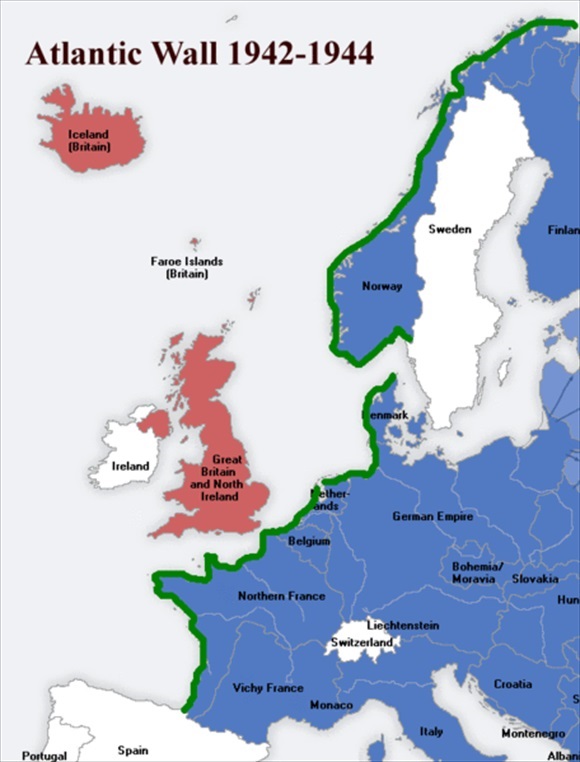 |
Above: Map of the 1,668-mile-long Atlantic Wall shown in green. The wall hugged the coastline from Norway to Spain in varying degrees and was most elaborate facing the English Channel. It consisted of an extensive system of imposing coastal fortifications built between 1942 and 1944 as a defense against an anticipated Allied invasion of the continent. In France the wall comprised a string of reinforced concrete pillboxes along the beaches or sometimes slightly inland, as well as mines and antitank obstacles planted on the beaches or in waters just off shore.
 |
 |
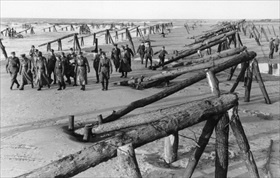
Left: In November 1943 Field Marshal Erwin Rommel took command of German Army Group B in occupied France. He also took control of the Atlantic Wall defenses on the French coast facing England. In this photo from April 1944, Rommel and his officers can be seen inspecting an installation of obstruction beams (Hemmbalken). Some were topped with mines. The Allies modified their original plans to land troops at high tide, closer to the shore, in favor of landing at low tide when the obstructions could be seen and avoided. The disadvantage with the revised plan was that it increased the length of beach to be crossed.
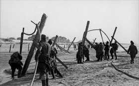
Right: In 1943 German troops had begun using hydraulic pressure hoses to assist in planting high wooden poles (Hochpfaehlen) in beach sand as obstacles to landing craft. In February 1944, on a tour of Channel beaches in Pas-de-Calais opposite England, Rommel ordered the technique used to place wooden beams, metal rails, and other obstructions along Normandy’s beaches. Nearly 11,000 were installed on the coastline where the Allies would land.
 |
 |
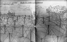
Left: Rommel sent his subordinate commanders sketches like the one depicted here for laying out wooden log and wire defenses against airborne assaults. Barbed wire and tripwires were to be strung between the poles. The complete system of wooden poles and interconnecting wires was called Luftlandehindernis.
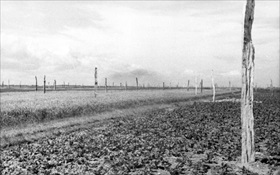
Right: “Rommel’s asparagus” (Rommelspargel) refers specifically to wooden poles used against aerial invasion. Wooden tree trunks and logs set in French fields and meadows in 1944 were intended to cause damage to military gliders and to kill or injure glider infantry. Though more than a million of these poles were erected, their effect on the invasion of Normandy was inconsequential.
Rare Color Footage: From D-Day to Liberation of Paris, 1944

World War II was the single most devastating and horrific event in the history of the world, causing the death of some 70 million people, reshaping the political map of the twentieth century and ushering in a new era of world history. Every day The Daily Chronicles brings you a new story from the annals of World War II with a vision to preserve the memory of those who suffered in the greatest military conflict the world has ever seen.