MOLOTOV-RIBBENTROP PACT ENDS FEUD
Moscow, Soviet Union · August 19, 1939
On this date in 1939 Soviet Foreign Minister Vyacheslav Molotov presented to Adolf Hitler’s Moscow ambassador a draft of a nonaggression pact between the two powers. The draft contained essentially everything the German serial aggressor could have wished for because it opened the gates for crushing neighboring Poland and solving the pesky problem of the “Polish Corridor,” the strip of land that separated East Prussia from the rest of Hitler’s Germany. For Soviet dictator Joseph Stalin, he viewed the proposed mutual diplomatic understanding as the stepping stone for restoring lost territories in the west (Belarus and the Ukraine) that had been ceded to Poland in the Treaty of Riga (March 18, 1921), which ended the Polish-Soviet War. Stalin’s “generosity,” as it were, came at a price: the nonaggression pact could only come into force if the pact’s secret protocol on future spheres of influence between the two heretofore antagonistic nations was signed at the same time. The secret protocol divided Poland into spheres of influence: German (west Poland) and Soviet (the “lost territories” in eastern Poland). Poland’s neighbor to the north, Lithuania, fell into the German sphere of influence because it was adjacent to East Prussia (“EP” on the map below). Finland, the Baltic states of Latvia and Estonia, and Bessarabia (which was part of Romania), fell into the Soviet sphere. The initial vivisection of Central Europe had the potential for “territorial and political rearrangements” as the two foxes rearranged the hen house after the outbreak of war in Europe. On August 20, Hitler agreed to Stalin’s demand and flew his foreign minister, Joachim von Ribbentrop, to Moscow for the signing ceremony. The Molotov-Ribbentrop Pact, signed in the late hours of August 23, 1939, provided for the amicable and immediate division of the country that lay between the two superpowers—the mechanics and protocol of which were well known because Czarist Russia and Prussia had partitioned Poland three times before in the 18th century. Hitler unleashed his forces on Poland on September 1, 1939, and Stalin’s forces moved into Poland from the east on September 17. On September 27, 1939, after Soviet forces had reached the predefined Molotov-Ribbentrop border, Poland was erased from the map of Europe.
![]()
![]()
Soviet-Nazi Non-Aggression Pact, August 23, 1939
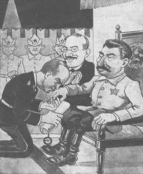 |  |
Left: “The Prussian Tribute in Moscow,” satirical cartoon of the August 1939 Molotov-Ribbentrop pact. Published in Warsaw’s Mucha weekly, September 8, 1939.
![]()
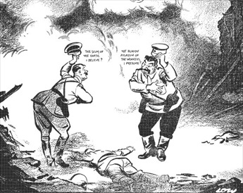
Right: “Rendezvous,” a political cartoon published in the London tabloid Evening Standard, September 20, 1939, shows the two ideological enemies, Hitler and Stalin, greeting one another over the sprawled body of Poland in the manner of Henry Morton Stanley and Dr. David Livingston greeting one another in November 1871 in western Tanzania, Africa (“Dr. Livingston, I presume?”), following the German and Soviet dictators’ September invasion of Poland. Hitler doffs his hat to Stalin, saying, “The scum of the earth, I believe?” To which Stalin replies, “The bloody assassin of the workers, I presume?”
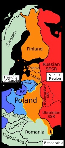 | 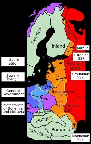 |
Left: Planned division of Central Europe according to the August 1939 Molotov-Ribbentrop pact. The yellow lines represent the planned borders. The Soviet Union and the Soviet spheres of influence are in red and tan, respectively. Germany and the German sphere of influence are in shades of blue.
![]()
Right: Actual 1939–1940 territorial changes are depicted in this map. The yellow lines represent the 1938 borders. The dashed black lines represent the borders of the Soviet states (SSR=Soviet Socialist Republics) in 1940. German annexations are shown in light blue. Purple depicts German-occupied territories and states: Norway, central Poland, and western Czechoslovakia.
British Historian Roger Moorhouse on the Impact of Molotov-Ribbentrop Pact and Its Secret Protocols
![]()

 History buffs, there is good news! The Daily Chronicles of World War II is now available as an ebook for $4.99 on Amazon.com. Containing a year’s worth of dated entries from this website, the ebook brings the story of this tumultuous era to life in a compelling, authoritative, and succinct manner. Featuring inventive navigation aids, the ebook enables readers to instantly move forward or backward by month and date to different dated entries. Simple and elegant! Click


